
LOGO of the NORTH WARNING SYSTEM OFFICE (NWSO).
NWSO is now part of theDirector General Aerospace Engineering Program Management (Radar & Communication systems) DGAEPM(R&CS)
NOTICE:
The information provided on this page is of a general nature only and is not supported or authorized in any way by the North Warning System Office, the Canadian Forces, or the Government of Canada.
The North Warning System was a joint US/Canadian program designed to replace thirty-one Distant Early Warning (DEW) Line radars, located across northern Alaska and Canada with eleven General Electric AN/FPS-117 Long-Range Radars (LRR) and thirty-six UNISYS AN/FPS-124 Short Range Radars aka “gap filler” (SRR) Unattended Radars (UARS). Three other LRRs have been installed at sites on the Eastern Labrador coast. Maintenance Control Facilities (MCS) are collocated with the Alaskan Regional Operations Control Center (ROCC) and Canadian Sector Operations Control Center (SOCC) to provide remote control of UAR sites. A satellite communications network provides connectivity between the LRRs, UARS, MCS, and the ROCC/SOCCs. Ground-to-Air-to-Ground (G/A/G) radios installed at LRRs provide G/A/G communications between the Alaskan and Canadian control centers and aircraft in those regions.
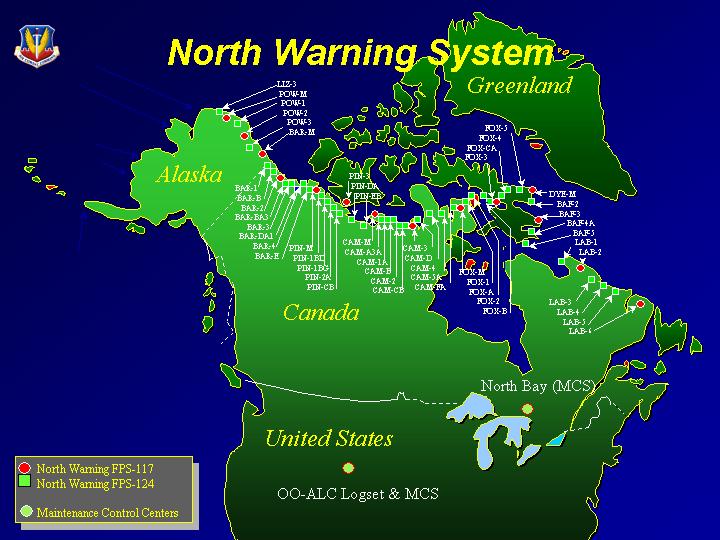
The North Warning System replaced the ageing Distant Early Warning (DEW) Line that was constructed in the early 1950’s. The North Warning System became operational in 1987/88. The following map depicts the approximate site locations. The Site Table below provides information on the various NWS sites. Additional information on the DEWLine can be found here.

North Warning System Commemorative Pewter Belt Buckle (1989)
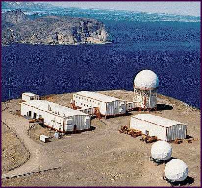
A typical East Coast North Warning System LONG RANGE RADAR SITE (LRR) in northern Labrador LAB-2, Saglek.
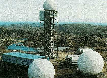
A typical North Warning System SHORT RANGE RADAR SITE (SRR) in northern Labrador LAB-4 Big Bay.
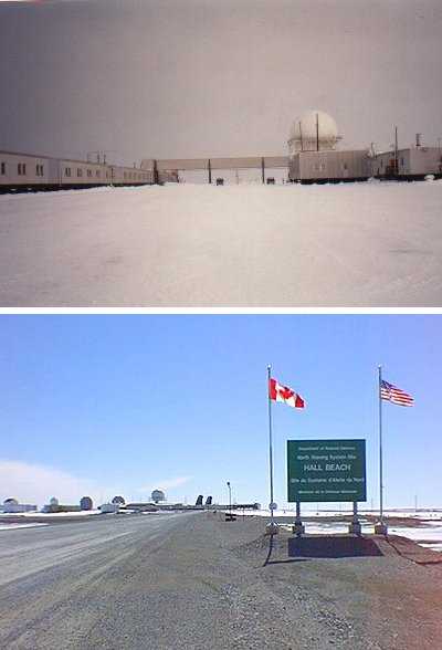
A former DEWLine Site, now North Warning Site, FOX-Main, Hall Beach NU.
NORTH WARNING SYSTEM SITE TABLE
Note: Click on site Geographic Place Name in the table below to go to site information in a new page.
- DEW = DEWLine
- DEW AUX = DEWLine Auxiliary Site
- DEW “I” SITE = DEWLine Intermediate Site
- DEW MAIN = DEWLine Main Site
- DEW REAR COM = DEWLine Rearward Communication Site
- NWS = North Warning System
- NWS LRR = North Warning System, Long Range Radar Site (AN/FPS-117 radar.)
- NWS SRR = North Warning System, Short Range Radar Site (AN/FPS-124 radar.)
- NWS LSS = North Warning System, Logistic Support Site
- LAT/LONG = Latitude and Longitude)
| NWS SITE NAME and LAT/LONG | SITE TYPE | GEOGRAPHICAL PLACE NAME | RADAR TYPE | IMPORTANT DATES |
|---|---|---|---|---|
| * | * | LIZ SITES | * | * |
| LIZ-2 69 44 08N 163 00 59W | Old DEW AUX NWS LRR | Point Lay, Alaska, | AN/FPS-117 | NWS Site Established 89/90 site deactivated 1994 |
| LIZ-3 70 36 32.65N 159 52 07.93W | Old DEW AUX NWS SRR | Wainwright, Alaska | AN/FPS-124 | NWS Site Established 1994 DEW Operations ceased Apr 1995 |
| * | * | POW SITES | * | * |
| POW-MAIN 71 19 38N 156 38 10W | Old DEW MAIN NWS LRR | Point Barrow, Alaska | AN/FPS-117 | NWS Site Established 89/90 |
| POW-1 70 54 37N 153 14 23W | Old DEW AUX NWS SRR | Lonely, Alaska | AN/FPS-124 | DEW Operations ceased Oct 1990 NWS Site Established 1994. Closed 2007 due to soil erosion = budget concerns. |
| POW-2 70 29 54N 149 53 22W | Old DEW AUX NWS LRR | Oliktok Point, Alaska | AN/FPS-117 | NWS Site Established 89/90 |
| POW-3 70 10 21.23N 146.51.18.03W | Old DEW AUX NWS SRR | Flaxman Island, Alaska AKA Bullen Point | AN/FPS-124 | DEW Operations ceased Apr 1995 NWS Site established 1994 |
| * | * | BAR SITES | * | * |
| BAR-MAIN 70 07 49.5N 143 38 21W | Old DEW MAIN NWS LRR | Barter Island, Alaska | AN/FPS-117 | NWS Site Established 15 NOV 1990 |
| BAR-1 69 35 53N 140 11 00W | Old DEW AUX NWS SRR | Komakuk Beach, Yukon | AN/FPS-124 | DEW Operations ceased 04 AUG 1993 NWS Site Established OCT 1990 |
| BAR-B 69 19 49N 138 44 13W | Old DEW I-SITE NWS SRR | Stokes Point, Yukon | AN/FPS-124 | "I" site operations ceased 1963 NWS Site Established JUL 1991 |
| BAR-2 68 55 23N 137 15 32W | Old DEW AUX NWS LRR | Shingle Point, Yukon | AN/FPS-117 | DEW Operations ceased JUN 1989 NWS Site Established Jun 1989 |
| BAR-BA3 68 53 9.22N 133 56 31.81W | NWS SRR | Storm Hills, NWT | AN/FPS-124 | NWS Site established NOV 1990 |
| BAR-3 69 26 35N 132 59 55W | Old DEW AUX NWS SRR | Tuktoyatuk, NWT | AN/FPS-124 | DEW Operations ceased 13 SEP 1993 NWS Site Established SEP 1990 |
| BAR-DA1 69 36 30N 130 54 00W | NWS SRR | Liverpool Bay, NWT | AN/FPS-124 | NWS Site established NOV 1990 |
| BAR-4 69 55 38N 128 58 13W | Old DEW AUX NWS SRR | Nicholson Peninsula, NWT | AN/FPS-124 | DEW Operations ceased 09 SEP 1993 NWS Site established OCT 1990 |
| BAR-E 70 00 59.02N 126 56 35.11W | Old DEW I-SITE NWS SRR | Horton River, NWT aka Malloch Hills | AN/FPS-124 | "I" site operations ceased 1963 NWS Site Established JUN 1991 |
| PIN-MAIN 70 10 17N 124 43 30W | Old DEW MAIN NWS LRR | Cape Parry, NWT | AN/FPS-117 | DEW Operations ceased AUG 1989 NWS Site established Aug 1989 |
| PIN-1BD 69 40 .96N 121 40 14.75W | NWS SRR | Keats Point, NWT | AN/FPS-124 | NWS Site established JUL 1991 |
| PIN 1BG 69 16 00N 119 13 00W | NWS SRR | Croker River, Nunavut | AN/FPS-124 | NWS Site established AUG 1991 |
| PIN-2A 68 50 23N 116 58 57W | NWS SRR | Harding River, Nunavut | AN/FPS-124 | NWS Site established SEP 1991 |
| PIN-CB 68 45 19.16N 114 56 21.58W | NWS SRR | Bernard Harbour, Nunavut | AN/FPS-124 | NWS Site established SEP 1991 |
| PIN-3 68 28 45N 113 13 32W | Old DEW AUX NWS LRR | Lady Franklin Point Nunavut | AN/FPS-117 | NWS Site established JUN 1989 DEW Operations ceased JUN 1989 |
| PIN-DA 68 29 09.26N 110 51 50.58W | NWS SRR | Edinburgh Island, Nunavut | AN/FPS-124 | NWS Site established OCT 1991 |
| PIN-EB 69 01 30N 107 48 10W | NWS SRR | Cape Peel West, Nunavut | AN/FPS-124 | NWS Operations ceased OCT 1991 |
| * | * | CAM SITES | * | * |
| CAM-MAIN 69 06 58.72N 105 07 08.83W | Old DEW MAIN NWS LRR/LSS | Cambridge Bay, Nuvavut | AN/FPS-117 | NWS Site established SEP 1989 DEW Operations ceased SEP 1989 |
| CAM-A3A 68 57 47.39N 103 45 34.33W | NWS SRR | Sturt Point, Nuvavut | AN/FPS-124 | NWS Site established OCT 1991 |
| CAM-1A 68 44 31N 101 51 17W | NWS SRR | Jenny Lind Island, Nuvavut | AN/FPS-124 | NWS Site established OCT 1990 |
| CAM-B 68 19 02.71N 100 04 09.15W | Old DEW I-SITE NWS SRR | Hat Island, Nuvavut | AN/FPS-124 | I site Operations ceased 1963 NWS Site established SEP 1991 |
| CAM-2 68 40 48.35N 97 48 38.84W | Old DEW AUX NSW SRR | Gladman Point, Nuvavut | AN/FPS-124 | NWS Site established OCT 1990 DEW Operations ceased 1992 |
| CAM-CB 68 38 10.37N 95 52 11.99W | NWS SRR | Gjoa Haven, Nuvavut | AN/FPS-124 | NWS Site established OCT 1990 |
| CAM-3 68 47 34.94N 93 26 25.17W | Old DEW AUX NWS LRR | Shepherd Bay, Nuvavut | AN/FPS-117 | NWS Site established JUL 1989 DEW Operations ceased JUL 1989 |
| CAM-D 68 35 41.34N 91 57 24.66W | Old DEW I-SITE NWS SRR | Simpson Lake, Nuvavut aka SITE 25 | AN/FPS-124 | "I" site Operations ceased 1963 NWS Site established SEP 1991 |
| CAM-4 68 26 13.06N 89 43 34.07W | Old DEW AUX NWS SRR | Pelly Bay, Nuvavut | AN/FPS-124 | NWS Site established SEP 1991 DEW Operations ceased 1992 |
| CAM-5A 68 39 53.306N 85 33 28.423W | NWS SRR | Cape McLoughlin, Nuvavut | AN/FPS-124 | NWS Site established JUL 1992 |
| CAM-FA 69 06 38.46N 83 32 23.57W | NWS SRR | Lailor River, Nuvavut | AN/FPS-124 | NWS Site established AUG 1992 |
| * | * | FOX SITES | * | * |
| FOX.MAIN 68 45 39.30N 81 13 35.20W | Old DEW MAIN NWS LRR/LSS | Hall Beach, Nuvavut aka SITE 30 | AN/FPS-117 | NWS Site established SEP 1989 DEW Operations ceased SEP 1989 |
| FOX-1 69 04 01.79N 79 03 55.15W | OLD DEW AUX NWS SRR | Rowley Island, Nuvavut | AN/FPS-124 | NWS Site established AUG 1991 |
| FOX-A 69 13 26.23N 77 13 48.97W | Old DEW I-SITE NWS SRR | Bray Island, Nuvavut aka SITE 32 | AN/FPS-124 | "I" site Operations ceased 1963 NWS site established AUG 1991 |
| FOX-2 68 53 56.24N 75 08 20.12W | Old DEW AUX NWS SRR | Longstaff Bluff, Nuvavut aka SITE 33 | AN/FPS-124 | NWS Site established NOV 1990 DEW Operations ceased 1991 |
| FOX-B 68 37 14N 73 12 58W | Old DEW I-SITE NWS SRR | Nudluadjuk Lake, Nuvavut aka WEST BAFFIN | AN/FPS-124 | "I" site Operations ceased 1963 NWS Site established OCT 1991 |
| FOX-3 68 39 02.56N 71 13 58.93W | Old DEW AUX NWS LRR | Dewar Lakes, Nuvavut | AN/FPS-117 | NWS Site establishedJUL 1989 DEW Operations ceased JUL 1989 |
| FOX-CA 68 38 51N 69 07 47W | NWS SRR | Kangok Fjord, Nunavut | AN/FPS-124 | NWS Site established SEP 1992 |
| FOX-4 68 28 21N 66 48 01W | Old DEW AUX NWS SRR | Cape Hooper, Nuvavut aka SITE 37 | AN/FPS-124 | NWS Site established DEC 1990 DEW Operations ceased 1991 |
| FOX-5 67 32 07.49N 63 47 11.43W | Old DEW AUX NWS SRR | Broughton Island, Nuvavut aka Qikiqtarjuaq aka SITE 39 | AN/FPS-124 | NWS Site established DEC 1990 DEW Operations ceased 1991 |
| * | * | DYE SITES | * | * |
| DYE-MAIN 66 39 52.46N 61 21 21.53W | Old DEW MAIN NWS LRR | Cape Dyer, Nuvavut aka SITE 41 | AN/FPS-117 | NWS Site established AUG 1989 DEW Operations ceased AUG 1989 |
| * | * | BAF SITES | * | * |
| BAF-2 64 57 28N 63 34 46W | NWS SRR | Cape Mercy, Nuvavut | AN/FPS-124 | JUL 1992 |
| BAF-3 (RES-X-1) 63 20 20N 64 09 28W | Old DEW REAR COM SITE NWS LRR | Brevoort Island, Nuvavut | AN/FPS-117 | NWS Site established OCT 1988 |
| BAF-4A 62 30 22.00N 64 31 06.183W | NWS SRR | Loks Island, Nuvavut | AN/FPS-124 | NWS Site established AUG 1992 |
| BAF-5(RES-X) 61 35 47.95N 64 38 20.40W | Old DEW REAR COM SITE NWS SRR | Resolution Island, Nuvavut | AN/FPS-124 | NWS Site established SEP 1991 Pinetree Operations ceased nov 1961 |
| LAB-1 59 59 15N 64 09 55W | NWS SRR | Cape Kakiviak Labrador | AN/FPS-124 | NWS Site established JUL 1992 |
| LAB-2 58 29 19.35N 62 35 08.00W | NWS LRR | Saglek, Labrador | AN/FPS-117 | NWS Site established NOV 1988 |
| LAB-3 57 08 07.6N 61 28 32.8W | NWS SRR | Cape Kiglapait, Labrador | AN/FPS-124 | NWS Site established AUG 1992 |
| LAB-4 55 44 30N 60 25 42W | NWS SRR | Big Bay, Labrador | AN/FPS-124 | NWS Site established SEP 1992 |
| LAB-5 54 42 53N 58 21 30W | NWS SRR | Tukialik Labrador | AN/FPS-124 | NWS Site established OCT 1992 |
| LAB-6 53 33 08N 56 49 46W | NWS LRR | Cartwright, Labrador | AN/FPS-117 | NWS Site established NOV 1988 Pinetree operations ceased JUN 1968 |
Please  comments or suggestions for additions or corrections to Brian Jeffrey at Brian@VE3UU.com.