
DEWLINE HISTORICAL DESCRIPTION
Topography
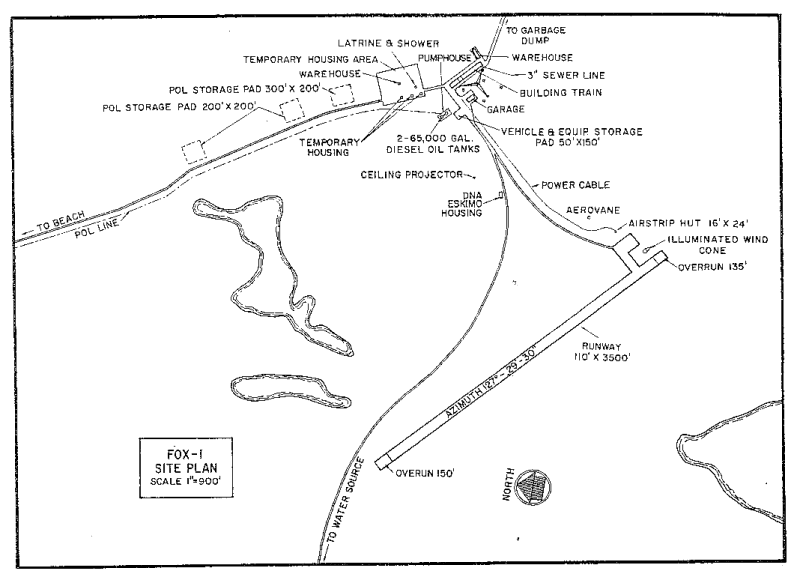
- FOX-1 on ROWLEY ISLAND, Canada, is situated on a flat plateau on the summit of the island at an altitude of 180 feet above sea level. this Auxiliary Radar Station occupies 3821 acres. The naturally poor drainage of the island is indicated by the numerous shallow, irregularly shaped lakes. The low shore generally slopes into broad tidal flats along most coastal sections.
Climate
- Annual precipitation, including snowfall, is approximately 7 inches, being heaviest in July and August and least in February. Snowfall is greatest in October and November and averages about 38 inches a year. Absolute minimum and maximum temperatures are minus 48 and plus 65 degrees Fahrenheit respectively
Water
- A round trip potable water haul of 4 miles is maintained summer and winter.
PHOTOS

Satellite Image – High level.

Satellite Image – Close-up.

Site Plaque, courtesy Jim Hartwell.

Launching houseboat made of oil drums. Courtesy John Higenbottam.


Construction Era Photos for FOX-1.
The pictures below were selected from the extensive collection of Markham Cheever, the DEWLine’s Superintendent of Construction from 1953 to 1957, before the Line went operational. (Click on picture to enlarge.)
-

- Beach operations. Aug 1956.
-

- Beach operations. Unloading a LCT. Aug 1956.
-

- Unloading construction material from a C-46 on the old airstrip. March 1956.
-

- Laying the foundation sills for the module train. Nov 1955.
-

- Polar bears foraging for food around the living quarters. Sept 1955.
The People.
The people in the photos below, also from the Markham Cheever collection, are displayed in the hopes that someone may recognize a father, grandfather, or friend who was involved in the construction of this particular DEWLine site. (Click on picture to enlarge.)
-

- Gen Twining’s DC-6 landing on FOX-1’s 3500 foot strip. Aug 1956.
-

- L to R: M. S. Cheever (in his signature red cap), Gen Twining, Vince Buttigieg. Sept 1956.
-

- L to R: M. S. Cheever, Vince Buttigieg, Ross, Gen Everett, Gen Twinning, BGen Wray, Alexander. Sept 1956.
-

- L to R: M. S. Cheever, Vince Buttigieg (receiving an award for bravery), Alexander, Gen Twinning, BGen Wray. Sept 1956.