
DEWLINE HISTORICAL DESCRIPTION
Topography
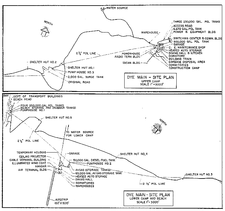
- DYE-MAIN at CAPE DYER Canada, is situated on 23,288 acres at the most easterly projection of Baffin Island into Davis Strait. The Upper Camp of this Main Radar Station occupies the highest available site on the eastern tip of a peninsula, 2300 feet above sea level. The Lower Camp and airstrip is located in an area about 8 miles southwest of the Upper Camp at an altitude of 1200 feet. Sheer cliffs, over 2000 feet high can be seen along the coastline in this area. DYE-M lies on the Arctic Circle and is the easternmost site in Canada. It is headquarters for DYE Sector and is the hub for several vital communication links.
Climate
- Annual precipitation is approximately 26 inches. Snowfall averages about 200 inches a year. Absolute minimum and maximum temperatures are minus 53 and plus 66 degrees Fahrenheit respectively.
Water
- The round trip water haul (summer & winter) DYE-M Upper is 6 miles and Lower, 4 miles.
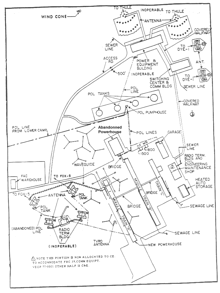
Building Layout Diagram Upper Site.
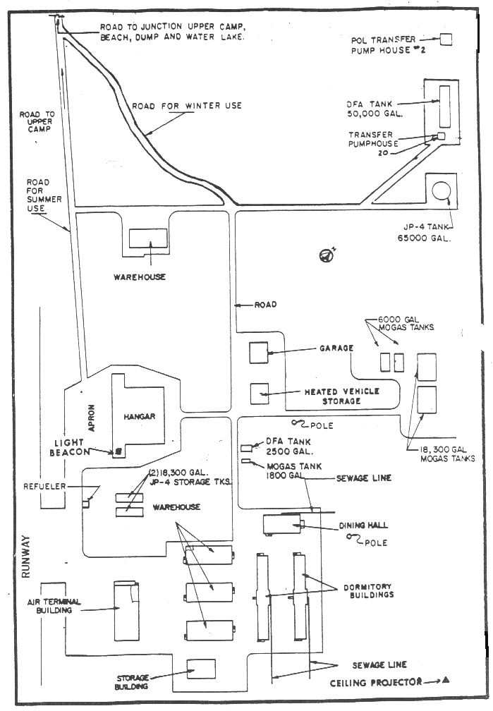
Building Layout Diagram Lower Site.
PHOTOS

Satellite Image – High level.

Satellite Image – Close-up.
Click to enlarge.
-

- DYE-Main, June 1957. Courtesy Ron Fry.
-

- Cape Dyer ice tunnel.


-

- DYE_Main, Lower Camp Christmas dinner, 1961. Courtesy Doug Johnson.
-

- Inuit housing, DYE-Main Lower Camp, 1961.

-

- DYE-Main Lower Camp, early 1962. Courtesy Doug Johnson.

-

- Entrance to the Upper Site. Taken in 1989.
Full size photos (below).


Snow Tunnel April 1960 Photo was taken looking back through the ‘snow tunnel’. This had been formed by upper layers of the tongue of a glacier continuing to move forward when the lower layers slowed down, or stopped, when they met rising ground. It was the moment, in glacial time, when the crest of the wave curled over. Courtesy Martin Allinson.

AA Tower. The only Radome that sat beside an AA tower that had a West facing dish and no East facing dish. To find the mirror image of this tower you would have had to go all the way to Alaska, to the other end of the Line. There were many AA towers with two dishes, but only two with only one dish. Courtesy Martin Allinson.

DYE Main Lower Camp. Taken from a helicopter in 1961. Courtesy Doug Johnston.

The Middle Camp Construction Camp. Taken June 1957. (Photo and comment by Ron Fry.)
The above picture was taken in the late Spring, June 1957. Middle camp was the living quarters for the laborer, construction workers. They lived in the insulated buildings pictured and took their meals up at the main dinning room in the modules where we lived and worked. Most of the laborers were French Canadian. Middle camp was just a little way South and East of the main (upper site) module train. Easy walking distance. Those guys worked as laborers up at the main site, not on the runway. It had been the living quarters for the guys that built the main station. And even the early electronic guys lived there for a while till the module train was ready. The laborers that lived there ate and used the recreation facilities in the modules.

The Lower Site Construction Camp. Taken May 1957. (Photo and comment by Ron Fry.) The lower camp was near the runway, but I’m not exactly sure how far away. Not very far. I didn’t get down there much. As I remember it was a fair distance down the lower camp. Anyway I guess south of the main site. I think you can see the fjord in the background behind the camp.

Sealift Activity.

The Sealift Area. Taken August 1957. (Photos and comments by Ron Fry.)
The Sealift
In August of 57 the Corps of Army Engineers brought an LSD (photo 1, below) up the fiord. They had frog men (photo 2, below) blast the under water icebergs and clear a path for landing barges (photo 3, below) to come in to shore. They had cats, cranes, etc. all manner of unloading equipment. It was really quite a spectacular thing. All heavy equipment and supplies arrived this way. The supplies were towed on skids and wagons (photo 4, below)by cats up the hill to the site.
Click to enlarge.
-

- Photo 1. Landing ship in the harbour.
-

- Photo 2. The frogmen clearing the harbour.
-

- Photo 3. The landing barge.
-

- Photo 4. Skids and wagons.
-

- Loading a wagon.
-

- Original Bombardier “snowmobile,” circa 1957. Photo and comment (below) courtesy Ron Fry.
I’m including a nice photo (above) of the snowmobile that we used to get around in. I mentioned that we didn’t get down to lower camp much. It was further away than we were allowed to walk. They had rather strict rules about going very far from the modules. You had to have transportation in the snowmobiles, carry a sleeping bag, and wear full arctic gear etc, The weather could change in an instant. One time I was wandering around at the upper airstrip and fog moved in. I was caught in a “white out” and wandered around in circles till I ran into one of the little orange flags that ran along the side of the runway. I just sat down and waited it out for an hour or so. Anyway the point is the rules made a little more sense to me after that.
The DEW Drop (Link to information and photos on DEW Drop.)
Comment on the DEWDROP (by David Hayes)
Here is a little bit more information for your web page. I worked on part of the system designated “612 nautical mile 100KW AN/FRC-47 drop between Cape Dyer Canada and Thule AB.” Your web page seems to be the only one that mentions this system. I worked at Thule circa 1960-61 shortly after the system was installed. The official name of that link was project “DEWDROP”.
The link went in late because equipment was lost. The GE transmitters were being flown to Thule from the lower 48. The plane developed engine problems, and some equipment was dumped overboard. The system was 24 channels of Lenkurt Electric carrier. Most of the channels were unusable most of the time because of severe fading not correctable by space diversity ‘combining’.
Originally, Americans supported the system. Later, Danish nationals were employed as technicians.
Dave Hayes
Comment on the DEWDROP (by Mike Bullough)
This relates to the “Dew Drop” system between Cape Dyer and Thule. Comments (above) regarding Danish personnel refer only to the site at Thule. Cape Dyer Dew Drop terminal was operated by Canadian contractor personnel.
What is not mentioned is that there was a submarine cable communications system from Cornerbrook in Newfoundland via Cape Dyer to Thule. This and the Dew Drop provided the two communications routes to Thule BMEWS. The submarine cable suffered breaks at Cape Dyer due to iceberg activity in the fjord. Subsequently the Cornerbrook and Thule sections were spliced in deep water bypassing Cape Dyer. The cable still suffered frequent breaks, due to ice activity at the Thule end, and trawlers at the Cornerbrook end. The cable was abandoned after establishment of the satellite link from Sunnyvale to Thule.
Mike Bullough
Goose Air Base & Resolution Island 1971 – 1973
Cape Dyer, Hall Beach, Cambridge Bay, Lady Franklin Point 1973 – 1978
A DEWLine Tragedy.
The crash of Nordair C-46, CF-NAD, occurred on 15 May 1967. Four people, 2 crew and 2 passengers, lost their lives. The incident happened during the final approach to Cape Dyer. The aircraft struck the snow covered ground 4500 feet short of the runway.
Click to enlarge.


1958 photos (below) are courtesy Jacques Lambert
Click to enlarge.


Construction Era Photos for DYE-Main.
The pictures below were selected from the extensive collection of Markham Cheever, the DEWLine’s Superintendent of Construction from 1953 to 1957, before the Line went operational. (Click on picture to enlarge.)
-

- Damaged reel of Styroflex cable. April 1056.
-

- Hauling construction material from the landing beach to the site. April 1956.
-

- Hanger material destroyed by fire in the Lower camp. April 1956.
-

- Installing the lateral UHF antenna waveguide through snow drifts. Feb 1957.
-

- Construction camp buildings buried in snow. Oct 1956.
-

- Completed DYE Main site showing the Dopplar tower and lateral antennas. Aug 1957.
-

- Overhead view of the Upper Camp airstrip showing an aircraft either taxing to the apron or taking off. June 1957.
The People.
The people in the photos below, also from the Markham Cheever collection, are displayed in the hopes that someone may recognize a father, grandfather, or friend who was involved in the construction of this particular DEWLine site. (Click on picture to enlarge.)
-

- M. S. Cheever in a quiet moment. April 1956.
-

- Earl Cline at the east end of the airstrip. April 1956.
-

- L to R: Cline, Wright, and Johnson. July 1956.
-

- Unknown “switchboard” operator at work. Feb 1957.