
DEWLINE HISTORICAL DESCRIPTION
Topography
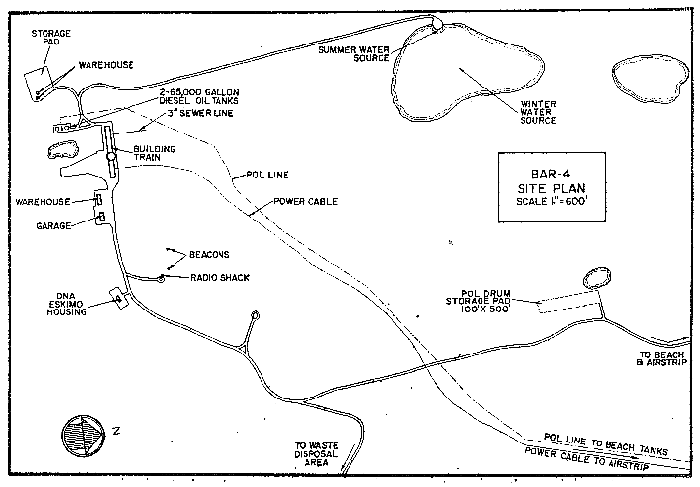
- BAR-4 on NICHOLSON PENINSULA, Canada, is situated on 2803 acres of relatively high ground at an altitude of approximately 275 feet above sea level. The airstrip is located on a low lying spit. The peninsula is tenuously connected to the mainland and extends in a generally northwesterly direction for 9 miles. The entire peninsula is surrounded by beaches. There is a sparse ground cover of mosses and grasses. Coastal cliffs 50 to 100 feet high lie to the west.
Climate
- Annual precipitation, including snowfall, is approximately 5 inches, being heaviest in August and September and least in March. Snowfall is greatest in October and November and averages about 15 inches a year. Absolute minimum and maximum temperatures are minus 47 and plus 81 degrees Fahrenheit.
Water
- A 2 mile round trip potable water haul is maintained summer and winter
PHOTOS

Satellite Image – high level.

Satellite Image – close-up.

DEW Line Long range Radar (LRR) site. TropoScatter billboard antenna on the left, radar tower on the right. Courtesy Marty Atherton.

NWS Short range Radar (SRR) site under construction. Fuel tanks on the left, unfinished radar tower is 100 feet high. Radome from old DEW Line site is in the background. Courtesy Marty Atherton.

Short Range Radar (SRR) satellite dish (uplink) (2 per site) replaced old troposcatter system as the means of passing radar and communications information. Courtesy Marty Atherton.

Old DEWLine site from top of SRR Tower, courtesy Marty Atherton.