
DEWLINE HISTORICAL DESCRIPTION
Topography
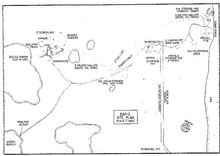
- BAR-2 at SHINGLE POINT, Canada, is situated on 2682 acres of coastal plain terrain that lies between two rivers at an altitude of 150 feet above sea level. The plain gently slopes toward the sea where it terminates in an approximate 100 foot bluff. The site is located immediately west of the Blow River in an area that is characterized by the western limits of the Mackenzie River Delta, along a remarkably straight section of the coast. Small steep walled draws (penetrating no more than 2 miles inland) occur along the coast at frequent intervals. The entire area supports occasional small shrubs and a light covering of grass and moss. There are thick growths of willow in the large delta area at the mouth of the Blow. The foothills of the Richardson Range begin approximately 25 miles inland from the station.
Climate
- Annual precipitation including snowfall is approximately 8 inches, being heaviest in July and August and lightest in March. Snowfall is greatest in October and November and averages about 30 inches a year which accounts for about 55 % of the precipitation. Absolute minimum and maximum temperatures are minus 61 and plus 88 degrees Fahrenheit respectively.
Water
- A 3 mile round trip potable water haul is maintained winter and summer.
Site Building Layout Diagram.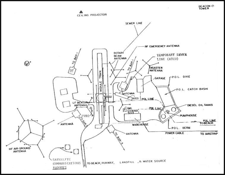
PHOTOS

Road from airstrip to site. Indigenous personnel housing in foreground to the right. Courtesy Ralph Howell.

Radar down for maintenance, July 1971. Courtesy Ralph Howell.
Construction Era Photos for BAR-2.
The pictures below were selected from the extensive collection of Markham Cheever, the DEWLine’s Superintendent of Construction from 1953 to 1957, before the Line went operational. (Click on picture to enlarge.)
-

- West end of the module train showing the piling that act as the foundation. The early stages of the radome platform construction can be seen on the right. June 1956.
-

- More drifting. The receiving doors can be seen on the right of the photo. March 1956.
-

- Drifts at the North side of the East end of the module train. March 1956.
-

- View of the snow-blown module train taken from the top of a snow drift. March 1956.
-

- More D-6’s being disgorged from the C-124. March 1956.
-

- A USAF C-124 delivering a Caterpillar D-6 loader. March 1956.
-

- Pilings in place for the module train foundation. Nov 1955.
-

- This is what happens when you inadvertently leave your truck window open! Nov 1955.
-

- Typical winter blizzard conditions. Nov 1955.
-

- View of the snow-blown construction camp. March 1956.
-

- Aerial view of the completed site. April 1957.
The People.
The people in the photos below, also from the Markham Cheever collection, are displayed in the hopes that someone may recognize a father, grandfather, or friend who was involved in the construction of this particular DEWLine site. (Click on picture to enlarge.)
-

- M. S. Cheever holding a fox skin. March 1956.
-

- Allanson having a well-deserved sleep. March 1956.
-

- J. D. Lewis and mosquitoes. July 1957.
-

- Wilson & Hope slip while removing an obstruction from the culvert. June 1956.