
DEWLINE HISTORICAL DESCRIPTION
Topography
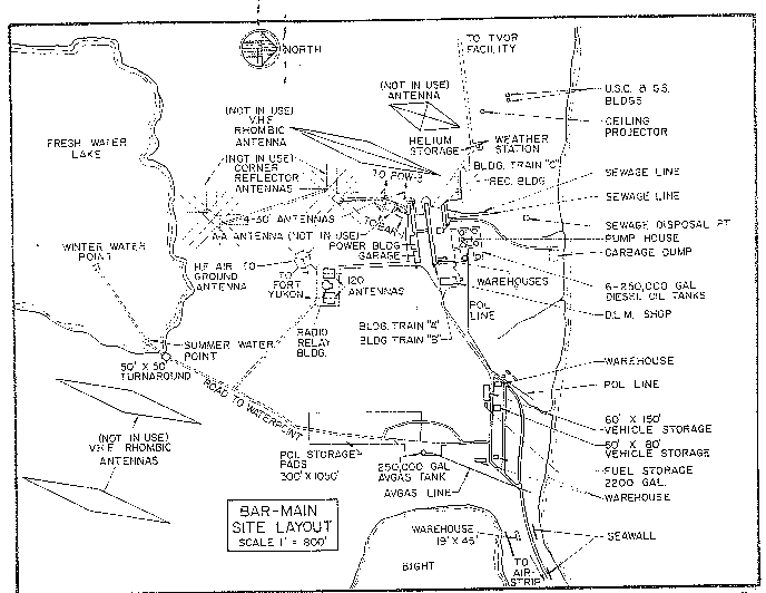
- BAR-MAIN on BARTER ISLAND, Alaska, is situated in 4500 acres of low lying, tundra covered terrain at an altitude of 50 feet above sea level. This Main Radar Station is the eastern most site in Alaska and is the headquarters for BAR Sector. During the thaw period the land surrounding BAR-M is swampy. The airstrip runs in an easterly direction along a narrow spit that is constantly being eroded by the sea. The highest elevation on Barter Island does not exceed 100 feet.
Climate
- Annual precipitation including snowfall is approximately 11 inches. Snowfall is greatest in January and October and averages about 24 inches a year. Mean daily temperatures run between a minimum of plus 3.8 to a maximum of plus 15 degrees Fahrenheit.
Water
- A two mile round trip potable water haul is maintained summer and winter.
PHOTOS

Satellite Image – High level.

Satellite Image – Close-up.
Trip Report: “A (1957/58) Visit to the BAR Sector” by Lynden (Bucky) Farris.
Four photos of the DEWLine cleanup project “Operation Clean Sweep.”
(Click to enlarge.)
-

- During the clean-up-1.
-

- During the clean-up-2
-

- After the clean-up-1
-

- After the clean-up-2
Miscellaneous Photos.
(Click to enlarge).

-

- Arial view, April 1998. Courtesy Chad Garber.
-

- Main power plant, May 1999. Courtesy Chad Garber.
-

- Supply barge and tug, 1986. Courtesy Landon Parker.
-

- Night time at the BAR-main airstrip. Courtesy Fred Teeter.
-

- Supply team, 1970. Courtesy Larry McConnell.
-

- Prototype Short Range Radar (SRR) on the left, under construction and before the radome was installed. Circa 1986, courtesy Landon Parker.

-

- Probably the most northerly US Post Office. 1956. Courtesy Dirk Van Nest.
-

- Generators of the Northern Lights!
Full size photos (below).

Original DEWLiners: Danny Gordon. Taken in the village of Kaktovik Christmas 2006.

Original DEWLiners: Isaac Akootchook. Taken in the village of Kaktovik Christmas 2006.

Sunbathing at BAR-M circa 1964, courtesy Stretch Grant.
Construction Era Photos for BAR-Main.
The pictures below were selected from the extensive collection of Markham Cheever, the DEWLine’s Superintendent of Construction from 1953 to 1957, before the Line went operational. (Click on picture to enlarge.)
-

- The BAR-Main construction camp main street. April 1953.
-

- The construction camp main street in the summer. Sept 1953.
-

- Curious owl in winter colours. Oct 1953.
-

- Supper time for the owl. 1953.
-

- Cargo and construction material organized on the beach. Aug 1953.
-

- The site’s hanger is beginning to take shape. March 1956.
-

- The module train is beginning to take shape. March 1956.
-

- Construction camp with some summer snow. Aug 1953.
-

- Site’s temporary radio hut. Aug 1953.
-

- Construction camp and airstrip with a beached LST in the background. Aug 1953.
-

- Construction material on the beach. Aug 1953.
-

- Oil drum storage area. July 1953.
-

- LST hunkered down for the long winter. Feb 1953.
-

- Beached LST’s disgorging their construction material. Aug 1953.
-

- Aerial view of the construction camp. July 1953.
-

- Sunset at 2330 (11:30 PM). July 1953.
-

- Cat train bringing construction material to the site. May 1953.
-

- Snow drift at a hut in the construction camp. April 1953.
-

- Atwell tent living quarters. April 1953.
-

- Snow covered living quarters. May 1953.
The People.
The people in the photos below, also from the Markham Cheever collection, are displayed in the hopes that someone may recognize a father, grandfather, or friend who was involved in the construction of this particular DEWLine site. (Click on picture to enlarge.)
-

- Don Holshizer. May 1956.
-

- L to R: Lack, BGen Wray, Goetze, & Ross, at lunch. April 1957.
-

- L to R: Pilot Al Mosely & Jim McCurdy in front of a Cessna 170. Oct 1953.
-

- A happy mob getting ready to depart BAR-Main. Oct 1953.
-

- L to R: Williamson, Heuser, Barry, Winchester, Kammerer, & Bachan having a bull session in the site office. Oct 1953.
-

- Fred Gordon. Oct 1953.
-

- Pete Lindstrom, structural engineer. Oct 1953.
-

- Bob Evans pouring over site blueprints. Oct 1953.
-

- L to R: Major Bachan, Merle Leonard & Walt Knopps. Sept 1953.
-

- Fred Gordon with Eskimo (Inuit) helpers. Sept 1953.
-

- L to R: Williams & Winchester. Note the fog bank behind them. Sept 1953.
-

- Paul Southwell. Sept 1956.
-

- Norn Weible in front of part of the module train. Sept 1953.
-

- L to R: Southwell & McKinney. Sept 1953.
-

- L to R: McKinney, Knopps, Marsh, Brazell, Abernathy, & Flora, Sept 1953.
-

- Vic Valentine with a D-8 Cat in the background. Sept 1953.
-

- L to R: Barry, Weible, & Reed. Chow time. Sept 1953.
-

- Radicians doing what they do best… chow-down. Sept 1953.
-

- Norm Weible conducting equipment tests. Aug 1953.
-

- Bud Rynearson. Aug 1953.
-

- L to R: Capt Anholt, unknown, & Mark Cheever in the Polar Bear Club. Aug 1953.
-

- Walt Knopps in front of ice piled up over the road. June 1953.
-

- Carl Brown. June 1953.
-

- L to R: Walt MacAdam & Red Kammerer at midnight. June 1953.