

[fb_button]
Sandwiched between the DEW Line and the Pinetree Line, the Mid Canada Line (MCL), also known as the McGill Fence was a series of military sites designed to function as the second line of detection. Its purpose was to detect enemy aircraft that had penetrated south of the DEW Line into the heart of North America. This system operated on the “Doppler” principle. Conceived during the “Cold War” in 1951 it wasn’t until January of 1958 that the line became fully operational. The MCL sites were strategically located along the 55th parallel from the Alaska border to the Atlantic Ocean. At its peak, it consisted of 8 Sector Control Stations and approximately 90 unmanned sites about 30 miles apart. With the 1960’s came improvements in technology and jet aircraft design in particular which rendered the MCL no longer economically feasible or strategically required, so it was shut down. The western sites were decommissioned in January 1964 and the eastern sites in April 1965.
Mid-Canada Line “War Stories” Do you have a story to tell? An amusing anecdote? A “War Story”? If you do, email your submission to Brian Jeffrey. Brian maintains this site on behalf of its founder, Larry Wilson.
SITE TABLE: To go to individual site pages, click on site name in the table.
Legend
- SCS – Sector Control Station.
- TROPO – Tropospheric Scatter Repeater.
- NOTE: Photos of Doppler Detection Stations (DDS’s) are accessible by visiting the parent SCS.
| SITE NUMBER | SITE TYPE | SITE PLACE NAME |
|---|---|---|
| 200 | Sector Control Station | HOPEDALE (LAB) NF |
| 300 | Sector Control Station | KNOB LAKE QC |
| 400 | Sector Control Station | GREAT WHALE RIVER QC |
| 500 | Sector Control Station | WINISK ON |
| 600 | Sector Control Station | BIRD MB |
| 700 | Sector Control Station | CRANBERRY PORTAGE MB |
| 800 | Sector Control Station | STONEY MOUNTAIN AB |
| 900 | Sector Control Station | DAWSON CREEK BC |
| 050 | Tropo Scatter Repeater | FORT ALBANY ON |
| 060 | Tropo Scatter Repeater | RELAY ON |
| 070 | Tropo Scatter Repeater | RAMORE ON |
MCL POL Supply Points
POL = Petroleum, Oil and Lubricants.
The Mid Canada Line
1958 – 1965
Maj. D.H. Thorne
The Mid Canada Line, an Air Defence Early Warning Line, stretching across Canada’s 55th parallel of latitude from Labrador to British Columbia, became operational in January 1958. Built in one of the worlds most difficult areas for construction and transportation, the rocky, rugged bush land, the thousands of lakes, the sub-arctic tundra, the treacherous muskeg, one writer viewed the successful completion of the line comparable with the building of the transcontinental Canadian Pacific Railway. It was considered a credit to Canadian ingenuity and enterprise, and it cost $224,566,830. And yet, by April 1965, just seven years and a bit later it had disappeared from the scene, gone with little fanfare, and now, 14 years later (1979) little remembered.
It all began in February 1953, when the Canadian and US Governments asked the Canada/US Military Study Group (MSG) “to study those aspects of the North American Air Defence System in general, and the early warning system in particular, which are of mutual concern to the two countries”. The MSG then asked the Air Defence Commanders of Canada and the US to prepare separate and independent briefs on the subject. By July 1953, RCAF Air Defence Command had completed its brief, and both this report and that prepared independently by the USAF, attached first priority to the construction of and early warning line along the 55th parallel. An analytical study of the same problem by the Canada/US Scientific Advisory Team (CUSSAT) also supported the reports. Consequently on 8 October 1953, the MSG recommended to both governments “That there be established at the earliest practicable date, an early warning line located generally along the 55th parallel between Alaska and Newfoundland”, and outlined their consideration as to the minimum operational requirements. By the end of November 1953, the Mid Canada Line had been approved in principle.
In October 1953, the RCAF was asked to review a Defence Research Board proposal for a Radio Fence System. To back up a bit, shortly after WWII, Defence Research Board (DRB) had demonstrated that a Doppler detection system could detect aircraft with a high degree of reliability. Professor G.A. Woonton of McGill University, discussed the use of a doppler system with US officials in Washington in early 1951, and because of the association with McGill University in its development, this system became widely known as the “McGill Fence”. During 1952, DRB established several tests which were extensively flight tested, and two reports were prepared with the results. DRB estimated an initial cost of $67,700,000 for proposals in the second report while the RCAF estimated the first proposal at $85,000,000. In the meantime, things were happening rather quickly. In December 1953, the RCAF undertook a study of the logistics and construction implications of a line along the 55th parallel. Tractor trains were organized to assist with the studies. One was dispatched eastward from Fort Nelson BC, to link up with a second travelling westward from Flin Flon Manitoba, and a third left Lake Nipigon in Ontario and headed northward for Lansdown House, this one under the command of the Army. The area between the east coast of Hudson Bay and the Atlantic is as many of you know first hand, very rugged terrain, and the study in this section was limited to photo interpretation carried out under the direction of the Joint Intelligence Bureau. The basic purpose of the study and the tractor trains was to select access routes based on the DRB report mentioned above. In February 1954, the RCAF Telecom staff advised that the DRB report contained insufficient data on siting criteria, and that a strip map some 15 miles wide, approximately along the 55th parallel would be needed to provide the necessary detail. Consequently, the main benefit derived from the tractor trains was confirmation that certain parts of the country could be crossed only in winter and then only by means of tractors and sleighs. Colonel (retired) F Colosimone, who provided some of the background information for this article, told me that the saga of the tractor trains would make an exciting newsletter series in itself.
A Steering Committee consisting of the Chiefs of Telecommunications, Construction Engineering, Air Plans, Air Operations and Materiel; the special Assistant to the Deputy Minister Construction and Engineering; the Army Chief of Engineering; a representative of DRB; a Treasury Board representative; the President of Defence Construction Limited; and a representative of the Department of Defence Production also began operating in December 1953. Early in 1954, at the direction of the Steering Committee, a Systems Engineering Group (SEG) was established, headed by Group Captain G. M. Fawcett (succeeded in August 1954 by Group Captain E. C. Poole), to study and make engineering recommendations for a target date of 1 June 1954. By April 1954, the SEG was off and running, and consisted of 3 RCAF Construction Engineering Officers, 13 RCAF Telecommunications Officers, 2 RCAF Operations Officers, 1 RCAF Supply Officer, and 10 Civilian Industrial, Electrical and Civil Engineers. During this same period, the Army was very busy producing accurate contour maps of a 15 mile wide strip along the 55th parallel from aerial photos taken especially for the purpose by Air Transport Command. The maps were essential for physical siting purposes and hence received top priority.
Concurrently, DRB continued testing doppler systems, and installed test systems both in the Ottawa area and in southern Ontario, working very closely, of course, with the SEG. On the target date of 1 June 1954, the SEG did not have it’s final report ready, but did submit an interim report which recommended the adoption of a single doppler line at a now estimated cost of $120,000,000. With amazing speed, and a rather surprisingly I think, on 30 June 1954, the cabinet approved the installation of the Mid Canada Line between Hopedale, Labrador and the BC/Alaska border, based on this preliminary engineering report from the SEG. The final SEG report was submitted 27 August 1954 through the Steering Committee to both the RCAF and USAF, and the Canadian and US Governments approved the Final Report in September 1954, although as stated, the Canadian Cabinet had already approved construction of the line some three months earlier, based on the preliminary report.
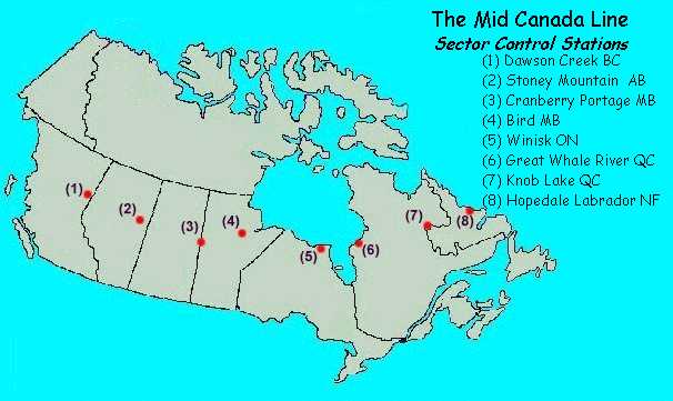
At this point, let’s pause for a minute and think of the enormous task this approval represented. When it was completed, the MCL consisted of 8 Sector Control Stations (SCS) located at Dawson Creek, BC; Stoney Mountain (Waterways), Alberta; Cranberry Portage, Manitoba; Bird, Manitoba; Winisk, Ontario; Great Whale River, Quebec; Knob Lake, Quebec and Hopedale, Labrador. These locations were all manned. In a double staggered line between, were 90 Doppler Detection Stations (DDS), all unmanned. All 98 stations were interconnected by tropospheric scatter communications systems and the Line was, naturally, linked to the overall Air Defence system ( DEW/Pinetree). As a function of identification several Line Clearance Aerodromes were established some 10 to 30 miles north of the line at appropriate traffic points, and we’ll go into those in a moment. These sites/stations were stretched across 2700 miles from Hopedale, Labrador in the east to Dawson Creek, BC in the west, and included 264 permanent buildings from small stores to large hangars; two major and 10 minor airstrips; a multitude of helicopter pads; 370 towers and radio masts of various sizes, including many over 350 feet high; 16 large scatter dishes, 322 diesel alternator units; plus literally thousands of items of radar, Doppler detection, radio relay, multiplex, point-to-point radio equipment etc. the transportation of all of these items represented over 200,000 tons of equipment, plus all the personnel involved. The terrain was forbidding, and most locations were accessible only by air, sea, or tractor train, or a combination of the three. Each site presented its own unique problem of water, services and power. And yet, despite the obvious problems, the Line was operational in just over three years.
Now, lets look at the basic system/plan which was approved, and how it was intended to work. As mentioned previously, the Mid Canada Line, or McGill Fence, was an application of the Doppler principle for the detection of aircraft. Basically, a transmitter and receiver were separated by several miles, with their antennae directed towards each other. The transmitter sent out an unmodulated continuous wave signal which was picked up by the receiver. In addition to the direct signal, the receiver also collected energy originating from the transmitter which had been scattered from fixed and moving objects in the path of the beam. The phase of this scattered signal generally differed from the phase of the direct signal which was used as a reference. A sufficiently rapid variation of this phase difference, such as that caused by the rapid motion of the object responsible for the scattering effect, could be detected as a beat frequency in the receiver output and was used to activate indicating devices. It was essentially a “trip-wire” system.
The Detection Stations were. as noted, unmanned, and included automatic standby equipment in the event of main equipment failure. This kept that section of the Line operating until technicians from the nearest Sector control Station could respond to the alarm and repair the main equipment. The information on aircraft crossing the Line was sent to the adjacent Sector Control Station where it was recorded. Here, it was determined which direction the aircraft were flying in crossing the line and identification was established through flight plan correlation. Unidentified crossings were reported to the Air Defence System to the south.
To meet identification specifications, the design authorities tied the Line into the Department of Transport’s Air Movements Identification Service (AMIS) net. The Line and the area it covered was designated Mid Identification Zone (MIDIZ). Aircraft had to file flight plans and obtain clearance to cross the Line, and aircraft not operating from a point in the AMIS net had to land at one of the Line’s designated clearance Aerodromes to obtain clearance before proceeding. In addition, surveillance radars were placed at heavy traffic points to track aircraft for identification purposes; these were located at Stoney mountain, Cranberry Portage and Knob Lake. To put your mind at rest, yes the Doppler system could differentiate between a flock of birds and an aircraft and did have some anti-jam features.
In the fall of 1954, the Trans Canada Telephone System (TCTS) was appointed Management Contractor. TCTS is not an incorporated company, but is an association of the major Canadian Telephone companies (seven in 1954) for the planning, operation, and division of revenue on long haul telephone traffic. TCTS, through its Project Agent, was responsible for the overall supervision, coordination, and timing of the entire project. The Project Agent had to work very closely with the Design Authority (the RCAF’s SEG), and had to provide engineering and consultant advice, technical reports, costing information, and detailed drawings and specifications to meet the system’s requirements as established in the “Final Report”. He had to develop a master time schedule and carry out siting and other field surveys as required, arrange for special packing, storage and transportation of equipment, and arrange for tests of equipment/systems as required. In short, TCTS was to turn over a complete and working system in accordance with the specifications indicated by the Design Authority. Enough to keep a guy (or two) occupied for a week (or two)!
In the winter of 1954-55, detailed engineering was started, and the preparations of specifications and drawings for buildings and equipment began. At the same time, base camps were established, and tractor trains and airlift started the supply of basic materials at caches and lake-heads. Early in 1955, Defence Research Board, the scientific advisors, confirmed that a 60 mile separation of Detection Sites was feasible rather than the closer spacing originally planned. By this time too, the Army had produced all of the one mile to the inch strip maps required, making it possible to select sites by [propagation studies, and the first siting teams went into the field.
Siting engineers flew all along the Line during the summer of 1955, and by September of that year, the Management Contractor (TCTS) and RCAF engineers, assisted by provincial land surveyors, had determined all the sites and electronic path loss checks of certain doubtful paths followed, along with the necessary detailed field survey work. And within that sentence lies another story.
It was clear from the start that the nature of the terrain in which the airlift of construction materials was required really left the helicopter as the only appropriate airlift vehicle. Since civilian operators at that time did not have sufficient helicopter strength for the operation, it was decided that the RCAF would have to meet this commitment. The result was the formation of the first unit in the RCAF to be equipped exclusively with rotary wing aircraft – 108 Communications Flight, born on 1 June 1954. Positioned initially at Bagotville, Squadron Leader T.R. Heaslip, then the most experienced helicopter pilot in the RCAF, was appointed CO. Orders were placed for six Sikorsky H34s and six Piasecki H12s. Six more H12s from Search and Rescue units across Canada were transferred to 108 Communications flight in addition, and six more were “borrowed” from the USAF. As the only pilot on strength for the first few months, Squadron Leader Heaslip got the job of ferrying the various helicopters from Morton, Pennsylvania and Bridgeport Connecticut. Sikorsky H19 (S55) helicopters were also employed from the beginning. Okanagan Helicopters in Vancouver was given a contract to train H19 pilots for the unit, providing in effect, conversion training on this type for pilots who had completed basic training on Sikorsky S51 helicopters at the Light Aircraft School, Rivers Manitoba. The first Okanagan graduate joined the unit in November 1954. Ground crewmen were posted in during the summer of 1954 and went through the trauma of first belonging to a unit with no airplanes, then to having a hanger full of helicopters with only one pilot (Heaslip) to fly them. Training went on at a rapid rate as the unit came up to strength, and on 31 May 1955,six H19’s left Bagotville for Knob Lake. June saw the unit begin the task for which it was formed – the transportation of men and materials for the construction of the Mid Canada Line, and Operation BackLoad II, the site proving, propagation path testing and site survey phase commenced. Often, the surveyors and their equipment had to be lowered to the ground from their hovering helicopter by mechanical hoist because the muskeg/bog wouldn’t support the weight of the machine in a conventional landing.
Each site required about two days to survey, and in between, the helicopters were used to haul other cargo. The site proving and survey parties and helicopters slowly worked their way west through the James Bay region to Moosonee, where a new main base of operations was set up in tents. Fuel caches had been placed at key positions in the area by tractor train during the preceding winter. The area west of Hudson Bay is almost entirely muskeg and the helicopters had to be very cautious in effecting landings. As the survey moved westward past Fort Severn, yet another temporary camp called Camp Seven was established
In September 1955 when this phase concluded, 108 Communications Flight had four detachments in the field operating from Knob Lake and Baie Comeau, Quebec; Cochrane, Ontario; and Grande Prairie, Alberta. Early in 1956, 108 moved to Rockcliffe (Ontario) and began the major job of hauling supplies and equipment to these sites. These activities continued through until February 1957. When its job completed the unit changed name to No. 5 Operational Training Unit and began a new tenure, this time training H21 and H34 helicopter pilots.
Detailed engineering work increased in the summer of 1955 and procurement of the myriad of items with its myriad of problems began with a target date for delivery in time for the tractor train and airlift operation scheduled for that winter. Fifteen major and over 70 smaller suppliers were involved from plants scattered all over the western world. I wonder how many volunteers they had for the job of getting all that stuff to the right place at the right time. The Project Agent (TCTS) handled most of the procurement, working through the Department of Defence Production(DDP).
As mentioned earlier, this amounted to over 200,000 tons of material – tractors, vehicles, construction materials, electronic gear, fuel, food, etc. – all of which had to be transported to a specific destination “somewhere” on the Line. About three months of the year is lost in this area because of fall freeze-up and spring thaw, as most Canadians are only too well aware. Marshaling areas were established at the end of rail lines and on major roads in the north. In the west, these included Dawson Creek, Slave Lake, Anzac, The Pas and Gillam which were served by rail, and Fort Black and Lac Laronge, among others that were on major roads. In the east, there were fewer options, and marshalling areas were eventually located at Moosonee, Timmins, Val D’Or, Montreal, Sept Isles and Knob Lake.
Common carriers were used to get material to the marshaling areas, and the most difficult problem here was the infrequent service to these areas. Our main railways run east-west, as any darn fool knows, and the relatively few north-south lines are feeders, with limited frequency service. Red “rush” tags didn’t mean much where the train only went once a week. In the west, some 200 miles of limited access roads were built as extension of country roads and trails, providing a link to most of the sites in BC and Alberta. One small snag developed when some material for RCAF Station Stoney Mountain Alberta found its way instead to the Stoney Mountain Penitentiary in Manitoba.
In Saskatchewan and Manitoba, material was transported from the marshaling areas by barge, boat, muskeg tractor, seaplane and skiplane, with helicopter usually needed for the final lift to the sites. During the winter of 1955/56, over 11,000 tons of material was hauled into this central area by tractor trains alone. These trains started out from Gillam, Manitoba, and Moosonee, Ontario, and at their peak, included over 400 sleds and 40 heavy tractors.
Hudson Bay was quite shallow, particularly on its west side, and this made it necessary for even relatively small ships to anchor off-shore for unloading by smaller barges and landing craft. Two 600 ton LCT’s were bought in the UK and towed across the Atlantic, converted in Canadian shipyards, and were sailed to and from the Bay under their own power. The larger barges were towed up by the DOT ships “N.B. McLean”, “d’Iberville”, and “Sorel”. All of the remainder were transported on the decks of both the DOT and commercial ships. Over 15 tons of navigation aids, buoys, channel markers, radar reflectors, etc, were set out in the Bay by the DOT ship “Edward Cornwallis” to permit safe passage. The DOT ships “d’Iberville”, and “CD Howe” made several trips very late in the 1956 navigation season , using their onboard helicopter to assist with unloading their cargoes. That late in the year, the sea was frequently too rough for days to permit landing craft to approach the ships.
Those discerning readers will no doubt already have noted the very considerable difference between the cost of the Line as stated in our first paragraph, $224,566,830, and the final SEG estimate of $120,000,000. There were many reasons for this and some were undoubtedly the result of questionable management decisions not controllable by the RCAF, but certainly, to be fair, more visible from the vantage point of hindsight. For example, Winisk on the west side of Hudson Bay was generally conceded to be extremely difficult for the physical landing of material from the sea. It was obvious that without a major dredging operation, lightering craft could not get near the site. consequently, Defence Construction Ltd. (DCL) engineers, together with marine consultants and engineers from the prime contractor, located and marked out a rock strewn beach suitable for use as a landing area. It was firm enough to support the required loads and could be cheaply cleared of the boulders and obstructions. Incredibly, nothing was done and material continued to move ashore by canoe and small LCM, until it became clear to everyone that the target dates could never be met doing it that way. The SEG provided a solution which involved the purchase of the two 600 ton LCTs from England mentioned previously. These ships, designed with flat bottoms, and with loading doors in the bows for assault landings, were also equipped with their own 50 ton derrick. The plot was that the cargo vessel would lie approximately six to seven miles off shore and would load the LCTs. The LCTs would time their sailings so as to enter the channel at high tide, and would land on the prepared beach through a natural channel which would be deepened. When the tide receded, the LCT’s would be left sitting on the beach and would be unloaded onto road transport through the bow doors. Again, incredibly, this didn’t happen and instead, DOT directed that the LCT doors be welded up and the RCAF planned and directed the building of a small harbour, large breakwater, turning basin and landing causeway in the same area as the beach. At considerable cost as you can imagine. Designed by Wing commander J.D. Shannon, the building of the harbour was no mean accomplishment, and its facilities permitted successful on-time completion of the landing operations. Was the expensive harbour really necessary? Since the other method was never tried to determine its feasibility, we’ll never know, but it is little wonder that the cost overruns were enormous.
On the “Air” side, although air transport was used all along the Line, it was, and had to be, the primary method of transport in Northern Quebec and Labrador. This included the extensive use of commercial carriers as well as the RCAF, and went of for almost two years. In fact, Maj Steve Zolmer at NDHQ with the Chief of Research and Development, worked on that section of the Line and recalls thinking that every civilian owned and military Canso aircraft in Canada must have been rounded up for the airlift. In this phase, more than 25,000 tons of material was airlifted. The last lap to the sites was necessary by helicopter.
Physical construction of the Line went into high gear during the summer of 1956 with the Bell Telephone field organization generally managing the job. With field construction time at a premium because of climate considerations, the use of prefabricated panels was a necessity. Most of the buildings were of steel panel construction with structured steel wind bracing. Buildings at the Control Stations had concrete foundations and floors while those at the Detection Sites were set on creosoted wooden sills or concrete posts. Along the 55th parallel, soil conditions varied from clay 100 feet deep to muskeg, sand, permafrost, shale and rock. Various foundation designs were therefore necessary. The steel towers of the system were set on foundations and guyed for a maximum permissible sway of six inches at the 350 foot level.
Locating suitable drinking water was also a problem, particularly at the western “muskeg surrounded” sites. Generally, available water had an unpalatable taste. Deep wells were dug at some locations but were not very successful.
The typical Detection Site consisted of a 28 X 60 feet prefabricated building divided into power, equipment and living quarters. Three diesel electric generators were housed at one end, one active and two on automatic standby. Heat exchangers on the diesel exhaust provided heat for the building. The detection equipment, communications equipment, fault alarm equipment, etc, was housed in the centre, and the living quarters with stove, refrigerator, bedroom, showers, etc was at the other end. Although designed to be unmanned, these sites had to have living quarters for maintenance teams who might have to remain for a considerable period because of weather conditions as well as in performing their maintenance function.
A typical Control Station had an Operations building which housed the electronics equipment, an Admin building , living quarters, a mess hall, two hangers, either a helicopter landing pad or a fixed wing landing strip, plus the usual service buildings such as heating plant, fire hall, etc. control Stations all had voice and teletype links to a designated Air Defence Control Centre, with alternate links through adjoining Control Stations in case of primary system failure. They also had voice and teletype circuits to a designated Department of Transport Air Traffic control Centre plus a circuit to the DOT meteorological office. All of this was in addition to the normal links with an RCAF Communications Unit (the equivalent of a Communications Squadron today).
The electronic repair and overhaul shop was both a laboratory and workshop. Maintenance at the unmanned Detection Sites consisted usually of sub-assembly and chassis replacement, and these were taken back to the Control Stations for repair. The equipment at the Detection Sites was remote controlled from this shop, and in addition, it contained the fault alarm system for the Detection sites which monitored some 30 different items at each.
In April of 1957, the four western Control Stations were manned by RCAF Operators, and although the identification was not ready, detection and operation began. By 1 January 1958, the whole Line was operational. By April 1965, it had been shut down. What Happened?
In April 1965, I was at Goose Bay, then an Air Transport Command Station, and I don’t remember much publicity attached to the closing, or any reasons given for general consumption, although those in Air Defence Command might have known. I recall only a general sense of relief that there were a few less “villas in the boondocks” to claim the attention of Career Managers. In August 1965 when I moved to Air Defence Command, the end of the MCL was a fait accompli and we had other things to occupy our time and talent. However, Colonel (retired) F. Colosimone recalls that if the Line was expensive to build, it was just as expensive to maintain and operate, particularly in view of the remote locations involved. The transportation and other difficulties didn’t go away just because the Line was up and running. Consequently, the RCAF did a very extensive study on the operating Line to accurately pinpoint the Air Defence benefits resulting as compared to the costs of operations, something almost impossible to determine before the Line was built. Among many things, the study found that by the time fighters were scrambled as a result of an MCL warning, the targets were under surveillance by the Pinetree Radars. This is very much an over-simplification, but to put it simply, the additional warning time provided by the MCL did not warrant the expense of operating the System. However, American authorities were very concerned about the protection of the eastern US industrial heartland. Consequently, the western half of the Line was closed in January 1964, with the eastern half remaining in operation until April 1965, when the Americans too became convinced that the Line was just not cost effective. While some low level coverage was lost, this was considered acceptable in view of DEW and Pinetree capabilities.
Although considerably less than successful from a cost effective viewpoint, there is no doubt that building the Line was a major pioneer undertaking and accomplishment, and is an important if little known part of our history. The lessons learned about construction in the sub-Arctic, management of very large projects, transportation, etc were invaluable. In addition, particularly in the east, MCL activities contributed immeasurably in opening up the country to both mining and hydro electric interests. And a project adding to our store of knowledge of this part of our country and opening it for development to the National good cannot be called completely unsuccessful.
Following information extracted from: Historical Reference Paper Number One
U.S. AIR DEFENSE IN THE NORTHEAST
1940 – 1957
By
Lydus H. Buss
DIRECTORATE OF COMMAND HISTORY
OFFICE OF INFORMATION SERVICES
HEADQUARTERS CONTINENTAL AIR DEFENSE COMMAND
Ent Air Force Base
Colorado Springs, Colorado
1 April 1957
The Pinetree radars from Hopedale, Labrador, to Pepperrell, Newfoundland, were to be tied into a Doppler detection line being built across Canada’s 55th parallel. Together these two lines were to form the Mid-Canada Early Warning Line.
The line across Canada, called the Mid-Canada Line, * was to run from Hopedale to Dawson Creek, British Columbia. It was being built by Canada. The line would have 90 Doppler detection (fluttar) stations and eight section control stations, all interconnected by microwave communications. The line was scheduled to begin operating on 1 July 1957.
A USAF-RCAF Operational Plan for this line, dated 1 June 1956, divided it into five operational segments called Doppler sectors. (42) Four of the five sectors were to be the responsibility of RCAF air divisions. The fifth sector was to be the operational responsibility of NEAC (North East Air Command). This sector, the smallest of all the sectors, contained nine Doppler detection stations and one section control station (Hopedale).
* For information on the Mid-Canada Line and the Distant Early Warning Line, see CONAD Historical Study 10, Seaward Extension of Radar, 1946-1956, pp64-69; and History of CONAD/ADC, July-December 1955, PP 68-77
As noted above, the Mid-Canada Line would connect with the Pinetree radars at Hopedale. This would provide a continuation of the line to St. John’s. There were seven heavy radars between Hopedale and St. John’s. To increase low altitude coverage along this line and provide some back-up for these radars, a small, light-weight radar (the AN/FPS-14), called a Gap Filler, was to be placed in between each of the heavy radars. (43) This required a total of six Gap Fillers.
Doppler Principle or Effect
Defined as : “An apparent increase (decrease) in the frequency of sound, light or other waves when the source and the observer become closer (more distant).” or “the phase or frequency change of a received signal due to the motion of the radiator in relation to the receiver.”
SITE MAP
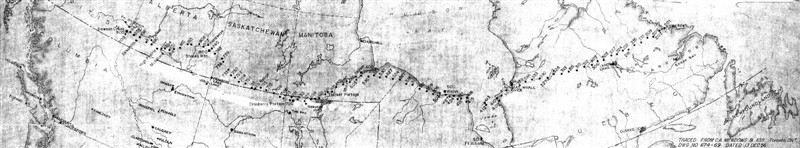
Mid-Canada Radar Line Site Map. Showing all sites as of 13 Dec 1956.