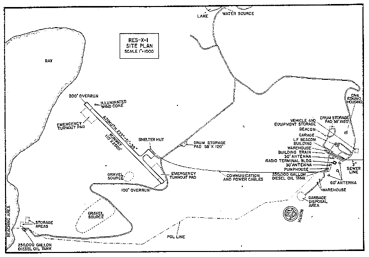
 (NB: Diagram is pre-North Warning System)
DEWLINE HISTORICAL DESCRIPTION
Topography
- RES-X-1 on BREVOORT ISLAND, Canada, is situated at an altitude of 1200 feet above sea level and occupies an area of 2524 acres. Brevoort is an irregular, hilly island consisting mostly of granite. It is located in Davis Strait, off the eastern coast of Baffin Island north of Cape Murchison about 250 miles south of DYE-M at Cape Dyer. RES-X-1 is a non-radar. rearward communications (relay) station. Housing and other station support buildings, such as garages, warehouses etc are similar in construction principle to those found at a typical DEWLine Auxilliary site.
Climate
- Annual precipitation, including snowfall, is approximately 18 inches, being heaviest from July to November and least from December to March. Snowfall is greatest in October and November and averages about 115 inches a year. Absolute minimum and maximum temperatures are minus 35 and plus 65 degrees Fahrenheit respectively.
Water
- A 3 mile round trip potable water haul is maintained summer and winter.

Satellite Image – High level.

Satellite Image – Close-up.
PHOTOS

Aerial view of the site runway, courtesy Carl Veilleux.

Site Contractor Sign, courtesy Carl Veilleux.

RES-X-1 circa 1961, courtesy Doug Johnston.

Site from the air, courtesy Dan McIsaac.

Air Terminal Building. (Courtesy Dan McIsaac).

Site Photo from the air, courtesy Zoltan Szabo.

Site Photo at night, courtesy Dan McIsaac.

On the airstrip 1988, courtesy Larry Wilson (shown).


Site photo 1992, courtesy Peter West.
Also:
RES-X-1 Space Path Loss Testing 1956 a photo story by Roger Collinson.
Construction Era Photos for RES-X-1.
The pictures below were selected from the extensive collection of Markham Cheever, the DEWLine’s Superintendent of Construction from 1953 to 1957, before the Line went operational. (Click on picture to enlarge.)
- Aerial view of the RES-X-1 airstrip showing the cliff/drop-off at the end. Makes for harrowing approaches and take-offs. Sept 1956.
- USAF C-123, tail number 4638, suffered a nose wheel collapse upon landing at RES-X-1. Feb 1957.
- Polar bear in the dump area. A VERY dangerous situation. Aug 1957.
- Shooting the bear was the only solution to this dangerous situation. Aug 1957.
The People.
The people in the photos below, also from the Markham Cheever collection, are displayed in the hopes that someone may recognize a father, grandfather, or friend who was involved in the construction of this particular DEWLine site. (Click on picture to enlarge.)
- M. S. Cheever, with his signature red cap and the bear. Aug 1957.
- Lohman with bear. You see how close the bear was to the main buildings. Aug 1957.
- Bob Alexander. Note the size of the bear. Bigger than two large men. Aug 1957.
- Frank Dawson standing near one of the RES-X-1 tropo antennas. May 1957.


